|
|
Bunker Hill Also Known As: Savage Butte |
||
| Online | Map | Photos | |
|
Established: |
1852 |
Nearest Town: |
Shedd, Boston |
|
Est. # Burials: |
< 20 |
Location: |
T 13S, R 3W, 8 |
|
Size in Acres: |
10.96* |
USGS Lat/Lon: |
442734N 1230407W |
|
Driving Directions: |
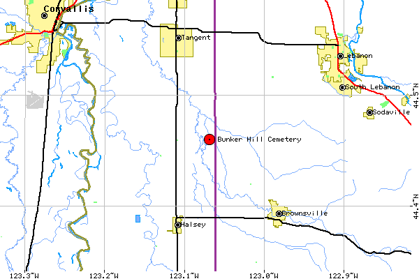
From O 99 and Shedd, East on Plainview Drive 1.6 miles, on South, Cemetery. |
|
Contact Info: |
Linn Co. Tax Assessor: Lot 100 |
The following information is transcribed from the WPA Linn County Cemetery Survey, researched & prepared by Leslie L. Haskin on 1/4/1939:
This cemetery...is situated on a rocky,
low hill or butte which, in this neighborhood, goes under two names. One name is
Savage Butte, so named after the man who first settled there, Americus Savage.
The other name is "Bunker Hill" and the origin of that name is an
interesting one. It runs as follows; according to neighborhood tradition:
Americus Savage settled on this land and built his first house directly upon the
summit of the hill. His nearest neighbor to the south was one Robert Elder. Now
Americus Savage and Robert Elder seemed to have been naturally incompatible.
Besides this incident occurred which made them active enemies. One night Richard
[sic] Elder took another man with him and went and knocked on Savage's door.
When Savage opened the door Elder hit him upon the chest with a black-jack.
Savage leaped out of the door and returned the attack. It was a battle royal, in
which Savage, being a very large man, came off the victor. That battle became a
neighborhood tradition and since the town of New Boston, or Boston, and the
Boston Mills was near at hand it naturally followed that any notable battle
should be known as the "Battle of Bunker Hill" and thus the place has
been called ever since.
To reach this cemetery drive east from the town of Shedd for a distance of about
two miles. Here will be found the Thompson Flouring mills, (Formerly the Boston
Mills) and a crossing of the Calapooia River. Continue eastward, after crossing
the Calapooia, for about one half mile when the butte may be seen to the south
at a distance of a short one-eight mile. It is a low rounding hill and must not
be overlooked or mistaken for the higher, more prominent Saddle Butte which
looms up about a mile further on. From the County road a gate leads through a
low pasture to the foot of the hill. [NB: How accurate are these directions in
2001?]
This cemetery tract consists of ten acres upon, and surrounding the butte, but
the cemetery proper is much smaller, the fenced and occupied part being only
four by eleven rods in extent. The land belongs to the Americus Savage heirs but
is set apart permanently for cemetery purposes, being so designated in Americus
Savage's will.
The cemetery is well fenced but otherwise little cared for. Much of the cemetery
proper is a rocky, outcropping ledge. The graves occupy the lower, eastern and
northern portion exclusively.
The earliest burial in this tract is that of Columbus, Son of A. (Americus) and
M. A. Savage, who died October 5, 1852. The earliest birth date recorded is that
of Americus Savage, June 9, 1815.
Historical & Biographical Notes:
Columbus, Son of A. & M. A.
Savage. 1851-1852. The first burial of record in this tract. Believed to be
an infant son of Americus Savage.
Mary Ann Savage. 1818-1886. Believed to have been the wife of Americus
Savage.
John Morgan 1833-1910. Believed to have been a pioneer of 1852.
John B. Cornett. 1832-1911. He was a pioneer of 1850.
Americus Savage. 1815-1876. The man who established this cemetery. He
took up the surrounding land as a donation claim. He owned the land on the
opposite side of the Calapooia River and sold a portion of it to Richard C.
Finley and P. V. Crawford for a site for a flouring mill, then known as the
Boston Mill, which was built some time during the 1850's. That was the second
flouring mill in this region. After a trip to his home in the East, following
(reputed) marital troubles, he returned to this butte on August 9, 1876. He
first cleared a spot on the north slope of the hill for a grave. He then
proceeded to the foot of the hill, wrapping himself in a red blanket, and
committed suicide by shooting himself. In a last message he instructed that he
be buried in the cleared grave site and with his head to the southward so that
he might look out over the pleasant northward scene. That his request was
complied with may be seen by visiting the grave. In his will he set apart ten
acres to be perpetually reserved for cemetery purposes. The fenced cemetery is
only a small part of this tract but all ten acres is still reserved in perpetual
trust.
Online Transcriptions:
In 1994 the Linn Co. Planning & Building Dept. prepared a history and conducted a survey of this cemetery - available at Jan Phillips' website.
Return to Linn County Cemeteries
References
used to prepare these cemetery pages are provided.
Lisa L. Jones prepared and is solely
responsible for the content of these pages.
Copyright 2001.